Generic selectors
Exact matches only
Search in title
Search in content
Post Type Selectors
Generic selectors
Exact matches only
Search in title
Search in content
Post Type Selectors

Shelf Road, Phantom Canyon

2 Reviews
Location Cripple Creek, CO
Rating Easy,
Length 66mi
Time 5hrs

Vehicle Types

Overview

Easy scenic loop leaves and ends in Cripple Creek.

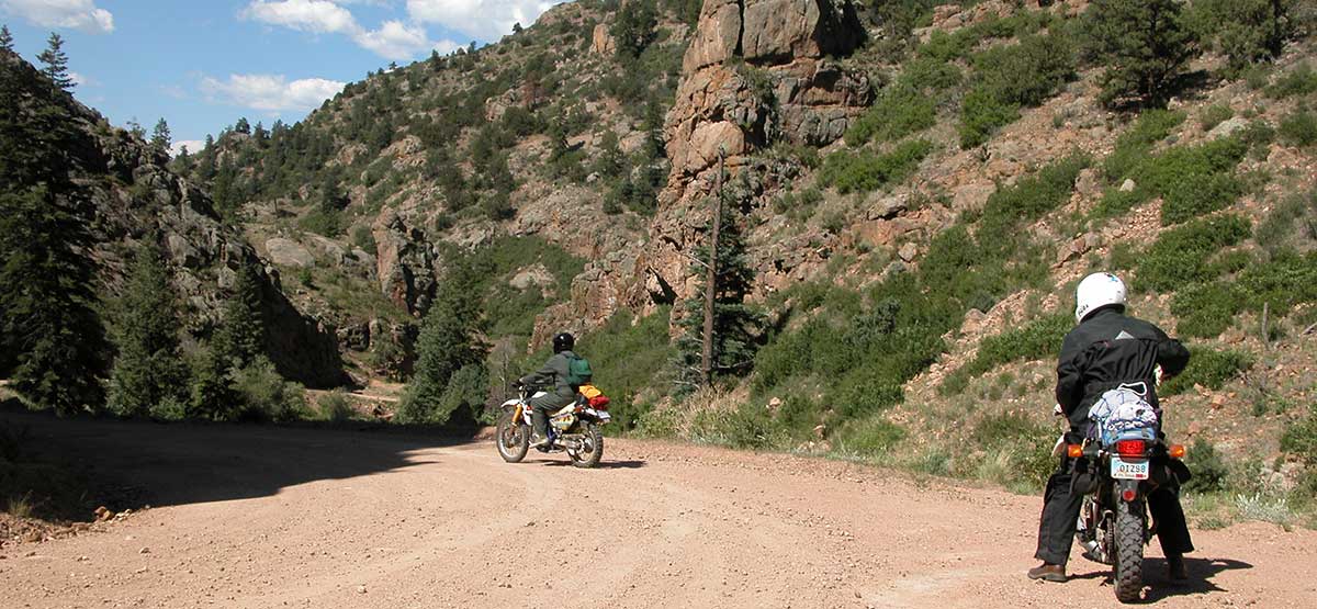
We start this route just south of historic Cripple Creek, where you can gamble in Colorado-style casinos. Many historic mining attractions can be seen along the route and along paved Highways 67 and 81, which circle through Victor and Goldfield. The loop described here is part of a well known BLM Gold Belt Tour and sees comparitively heavy traffic on summer weekends. A network of 4×4 roads departs from the Shelf Road west of Sand Gulch Campground and south of “The Bank” Campground, a popular climbing area (see map). Unlicensed vehicles can ride on these side roads but not on the main loop. Red Canyon Park has picnic area in dramatic red rock formations.

Rating

Easy
Trail Ratings Defined

Phantom Canyon is a car road but has a few narrow, high spots. Shelf road is rougher, steeper and narrower but can be done in a highclearance, two-wheel-drive SUV when dry. Check status before you go as roads sometimes close due to washouts.

Stats

Length

66mi

Time

5hrs

High Point

9,700ft

Best Time To Go

May-Oct

Current Conditions

(719) 269-8500BLM Royal Gorge Field Office

Check the Weather

No updates yet.

Provide an Update

free GPS downloads

Reviews

Rate this trail on a scale of 1 to 5.


×

Mike and Lisa Steeves says

We traveled these roads during August 2018. Phantom Canyon Road These roads are generally considered to be 'easy', in the category of 'family fun runs'. None of them require a 4-wheel drive (unless one goes off on the side roads, which can quickly become somewhat challenging). The biggest 'issue' we have found is some sections are heavily washboarded, which can cause handling difficulties unless one slows down considerably. And, the lower section of Old Stage Road really should be avoided. "Target shooters" have really trashed that section, leaving areas littered with shot up paper targets, plastic bottles, cans, shot up target frames, and other such refuse. And every sign - road, forest service, fish and wildlife ... all of them ... were shot to hell. I guess the exercise of one's Second Amendment rights includes the right to trash the countryside. Also, we encountered a number of yay-hoos on that section, driving like morons with no regard for anyone else. In one instance, we were passed by a Tahoe and a Liberty; the Tahoe was fishtailing all over. Leece says, "We'll see him in the ditch" or words to that effect, and gosh darn and golly, Sergeant Carter, but right around the next hairpin, there he was. He bashed in the entire driver's side, kissing the rock face. Good thing no one was coming the other way. We started from where Phantom Canyon intersects US50 just outside Canon City, and went up to Victor, then back down by way of Upper Gold Camp and then Old Stage. The rest of these roads were quite enjoyable, very scenic, quiet, drivers were friendly, and a good time was had by all. Shelf Road We traveled the Shelf Road from Canon City north to Cripple Creek. We took Field Avenue from US 50 in Canon, straight up through residential neighborhoods to the intersection with Red Canyon Road (CR 9). This is paved for about 9-10 miles after that, till CR 9 takes a hard right, the pavement ends, and Shelf Road begins. The road is generally well-maintained, with some areas of mild-to-moderate washboarding. A 4WD is not necessary on this road, though some of the side trip options do require 4WD. We were in a stock Wrangler JLU; the Jeep was not in the least challenged by this road. The main thing is to take it slow. We kept it under 15 for most of the way though pushing it up to 20-25 in some spots was feasible. The road is narrow, no guardrails, with some spectacular dropoffs. The hairpins usually have quite enough room to pull over so as to make room for oncoming traffic. If not, it's easy enough to back up a short distance, as there are also sufficient wide spots along the road to let traffic by. We only met three or four vehicles coming the opposite way, and saw a Dodge van and a small Subaru on the road as well. The road is not difficult to follow, despite several intersecting roads. You do have to pay attention, however, as it is quite possible to get lost for a bit up there. There is decent phone service (Verizon) for most of the route, so Google Maps is probably your best friend. GPS is solid as well. This is not a high mountain trail. Don't expect broad vistas of snow-covered peaks. What you will see are some magnificent canyons, creeks, and a changing forest type. We picked up gambel oaks at about 6500 feet, aspens shortly after and many more after 7200, and spruces and pinions starting at 7500. We topped out near Cripple Creek at 9478. There were still some wildflowers out; blue bonnets, Indian paintbrushes, Queen Anne's lace, yellow coneflowers, Russian thistles.
×

Chris says

I have done this route a few times and it has yet to disappoint. I have don't it in both a 2019 Ford Ranger and a 1993 Nissan Pathfinder. The Shelf Road is a little bit tougher if heading North simply for the steep inclines along the way. For the Phantom Canyon side I have done it during the winter. There will be snow in those months, but usually doable with no major problems. For an extra side bit to extend the loop, use County Road 69 going to F24 to Red Canyon Park. Makes for a nice challenge for those looking for one.
by Webolutions Digitial Marketing Agency


Cancel Agree