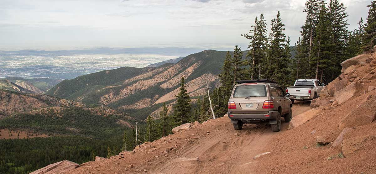
Trail ends at a large gate below Mt. Baldy and south of Almagre Mountain. You can hike to both peaks. On a clear day, enjoy views of south Colorado Springs below. Great camp spots along first half of trail where it passes through Frosty Park. Difficult Eagle Rock, Trail #93, connects to Mt. Baldy Trail as it passes through Deer Park. Suitable for stock high-clearance SUVs provided no significant rock slides have occurred along F.S. 379A.
(719) 636-1602Pike N. F., Pikes Peak R. D.
Check the WeatherNo updates yet.
Provide an Update09/01/2024
Submitted by Joe
The trail from the Colorado Springs side is fairly easy with a few rock obstacles. Coming in off the South Slope is steep, rutted and slick with scree. Some sections are very rocky so tire placement and some speed is a must. As for going the last mile to the gate just below Mount Baldy is very rough. Spotters will most likely be a must for drivers. Some of these sections require good tire placement and avoiding larger obstacles obstructing the use of the full trail. This shelf road is very narrow and you have very few places to pass and the only real turnaround is at the end of this trail. I would rate this as a moderate not and easy trail due to the rocks and exposure on the shelf road.
08/23/2021
Submitted by Darren
The trail is narrow and slick. Thankfully there were no recent rock slides to block our path. Not knowing the condition of the remainder of the trail, we did make the decision to hike the last mile to the gate. The views do not disappoint and it is well worth the trek for those that are not faint of heart.
08/01/2021
Submitted by Chris
Attempted the Mt. Baldy (Mt. Almagre) trail on 7/30/21. Road 379A has severe washouts/ruts along the narrow shelf, making the shoulder/edge of the road VERY unstable and dangerous. Approximately 1 mile before the gate, the road is completely blocked by several large boulders that broke free from all the rain. It is possible to hike or motorbike past the boulders but is otherwise impassible by any other vehicles. Must back down approximately 1/2 mile over “rock garden” conditions along the very edge of the unstable road with no shoulder. The trail is listed as “easy”… would consider “sketchy” at best, due to road degradation from heavy rains so far this season, and extreme pucker factor along 379A.
9/25/2020
Submitted by Adam
As the previous update states, this trail is not easy. It may have been maintained when scouting was done but this road hasn’t seen maintenance for years. Moved several large rocks out of the trail ahead of me before I decided it wasn’t worth the chance in my stock Crosstrek. Turned around at the campground area. If you want a bit of a challenge that’s doable in a stock Crosstrek or similar check out LaSalle pass
08/08/2020
Submitted by Brian
This trail was easy a few years ago and I’ve been on it 3-4 times now. It’s not an easy trail now. There’s a washout area I had 2 wheels on the ground at and on the last stretch of road there are 2-3 pretty tough obstacles. It’s pretty eaten up and I barely got over them. I would say this is a high moderate now. I’ve done others recently that was easy… Clear Lake, California Gulch, Hurricane Pass, Governor Basin… Those weren’t even comparable to this.
05/01/2020
Submitted by Jack
Tried on May 1st, the last leg on 379A was still too snowy and slick on the shelf road. Don’t attempt yet!