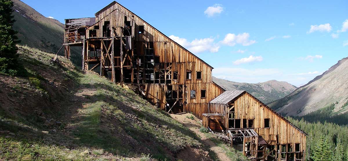
Located between Mount Massive and Mount Elbert, this trail climbs to one of the largest and bestpreserved mill structures in Colorado. Incredible views above timberline on way to Iron Mike Mine. Terrain is exciting and challenging after Waypoint 02. Water crossings are fun. Area before Waypoint 02 sees heavy traffic by hikers. Two famous fourteener hiking trails leave from established campgrounds.
(719) 486-0749San Isabel N.F., Leadville R.D.
Check the WeatherNo updates yet.
Provide an Update09/19/2023
Submitted by Mark
Ran this yesterday in a 2011 Rubicon on 35’s. Unlocked, swaybar connected. The trail is easy (3-4/10) with a couple short moderate (5/10) sections. Passable by any stock 4WD with a modicum of care. AWD vehicles should stay on the pavement as their designers intended. If you take the Iron Mike spur it’s moderate (5/10) up till the one real obstacle (8/10). You drive through a creek to wet your tires, which then makes traction fun climbing the rocks on the other side. There is a permanent winch point available. Use it if you need. There is a bypass to the right. Don’t use it. The Forest Service currently has a tree blocking it. If people keep going off the trail to avoid this gatekeeper obstacle, the entire trail will be closed. Once past this obstacle, the trail reverts to moderate (4-5/10).
The scenery in the area is lovely, the wildlife very good. The Champion Mill buildings are in excellent condition, all things considered.
08/08/2022
Submitted by Andy
I rode Half Moon Rd out to the champion mine in my Jeep Gladiator on September 8, 2022. It was a great ride and the scenery is equal to anywhere in Colorado. The road is rough and steep in spots. I stayed in low range and moved over the obstacles at slow speed. Water levels were low. The last time I rode the trail I judged the creek to be too high to cross on my motorcycle (a foot higher and running fast).
10/09/2021
Submitted by Jon
I drove up 110J last week. It is really rocky and rutted. I had a hard time with a stock FJ Cruiser. I kept bottoming out. This road is very narrow and there is no place to turn around until you get to the obstacle, which is a big boulder across the road on the other side of the creek. There is one switchback that you must make in one pass. There is no room to back up and it is really steep. It is probably not bad with a lifted 4X4. The problem is that if you encounter another vehicle, you are going to have a bad time.
06/26/2019
Submitted by Randy Jarman
Avalanche trees blocking trail approximately 1/4 mile after the 2nd water crossing.
07/23/2018
Submitted by Funtreks
F.S 110.J is closed 1.1 miles after Waypoint 02. You can still cross the creek and drive the obstacle, however, the trail is officially closed after this.
8-6-2023 we drove the trail up to the Champion Mill. The trail is narrow through the trees and a little...See More